
|
Quick Reference Guide
All the geographic conversions are based on the document Geomatics Guidance Note Number 7, part 2, Revised July 2012 released by International Association of Oil & Gas Producers.
The ellipsoidal distances are computed with the Vincenty's formulae.
Through this application you can perform a quick conversion between two coordinate reference systems.
In the main window you can convert a tuple of coordinates.
There is also an option to automatic convert a list of coordinates stored in a text file.
And is also possible to calculate the geodesic distance between two points.
Single Point Conversion
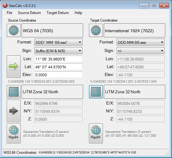
Define the Source and the Target Coordinate Reference Systems.
Manually by clicking on the three buttons to define Ellipsoid, Projection and Conversion Paramenters.
Automatic by loading a predefined Datum through the appropriate menu command.
Click on the arrow buttons to select the method of input.
If you select the geographic coordinates input, then you can set the format of the coordinates.
Coordinate List Conversion
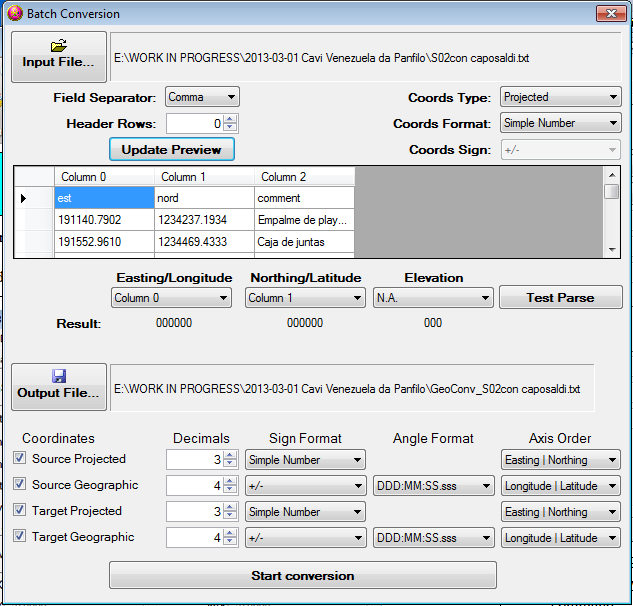
Define the Source and the Target Coordinate Reference Systems.
Manually by clicking on the three buttons to define Ellipsoid, Projection and Conversion Paramenters.
Automatic by loading a predefined Datum through the appropriate menu command.
Click on the "File => Batch Conversion..." menu to open the appropriate form.
Set the name of the file where to save the conversion results.
Once everything is done just click on the Start conversion button to create the file with the converted coordinates.
Geodesic Distance Calculation
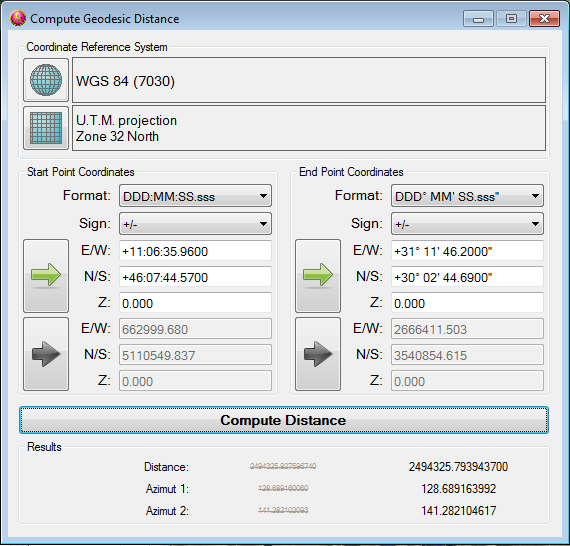
Define the Source and the Target Coordinate Reference Systems.
Manually by clicking on the three buttons to define Ellipsoid, Projection and Conversion Paramenters.
Automatic by loading a predefined Datum through the appropriate menu command.
Click on the File => Calculate Distance menu to open the appropriate form.
Check and eventually set the Coordinate Reference System.
Click on the arrow buttons to select the method of input.
If you select the geographic coordinates input, then you can set the format of the coordinates.
Input the coordinate of the start and the end points of the geodesic line.
Click on the "Compute Distance" button to view the resulting distance in the fields at the bottom of the window.
2013-04-05 GeoCalc - Rev: 0.3.4.2
Corrected a bug in the GeoLibrary.
2013-03-27 GeoCalc - Rev: 0.3.4.1
Corrected a bug in the GeoLibrary.
2013-03-27 GeoCalc - Rev: 0.3.4.0
Added the possibility to load/save the C.R.S. in a ESRI prj file. Various code optimizations.
2013-03-18 GeoCalc - Rev: 0.3.3.0
Batch conversion now can handle list with more informations and also with header line. Bug fixing.
2013-03-12 GeoCalc - Rev: 0.3.2.0
Batch conversion bug fixing. GUI improvements.
Get application | Source code not available
2013-01-30 GeoCalc - Rev: 0.3.1.0
Added the distance computation between two points. Bug fixing.
2012-11-05 GeoCalc - Rev: 0.3.0.0
Code splitted in a dll and an interface program. Bug fixing.
2012-09-18 GeoCalc - Rev: 0.2.0.0
Added the ability to convert a list of coordinates.
2012-09-14 GeoCalc - Rev: 0.1.0.0
New application to convert coordinates. The idea of the previous spreadsheet has been converted in a more user friendly application.
The formula inside are compliant with OGP Guidance Note 7 part 2.


